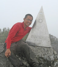


Mt Pulog at 2922m is the second highest mountain in the Philippines and the highest in Luzon island. I took the easy Ambangeg route and reached the summit at 5.30am on 24 January 2009.
From Baguio, the bus (P72) took 3 hours to reach Ambangeg (Am-bang-nge). I registered with Mt Pulog National Park and had to pay a registration fee of P780 and watch a 15 minutes orientation video. After the registration, climbers could hike the 10km uphill trail (3-4 hours) to the Ranger Station or hire a motorcycle to take you up in 40 minutes. I chose the later (P300 return).
The ranger greeted me and offered a room for P20. After making arrangement with a guide (P500) to start the hike at 2am, I proceeded to make myself comfortable, doing a short tour of the village and the farm. I saw a few jeepneys and found out that they were hired from Baguio by a group of climbers who were already in Camp 2. The Ranger Station had a ‘comfort room” and cooking area and they obliged me with a flask of hot water when I asked for it.
The hike to the summit wasn’t especially difficult. It was actually a gradual climb to the summit through mossy forest and grassland. At the beginning it was very warm (with my layers of clothing) but later it began to get very cold especially when the thick fog came in. We reached Camp 2 after 2 hours and after a 30 minutes rest, we started our climb again. Camp 2 was already inside the grassland area and the trail was narrow and muddy. The climb to the summit took 1.5 hours.
Reaching the summit was an anti-climax. The fog was thick and wet. Strangely, the summit had a cluster of dwarf bamboos with maze like openings that allow hikers to hide from the cold wind. I sat there waiting for the sun to rise and hopefully for a warmer weather. No such luck.
After snapping a few photographs, I started my hike back to the Ranger Station at 7am and reached there at 9.05am. My motorcycle driver came at around 10am to take me down to Ambangeg because the bus from Kebayan towards Baguio will arrive around 1pm. I did not want to miss that bus.
The next day I hired a taxi to take me to Mt Santo Thomas (2220m). It was a nice way to have a good view of Baguio and the surrounding mountains.

looks like the weather wasn't too good! anyway congrats on climbing the highest in luzon! try mt. apo too and mt. kanlaon!
ReplyDelete